
thermal binocular for long-range day and night surveillance, reconnaissance, and thermal target detection in demanding environments.
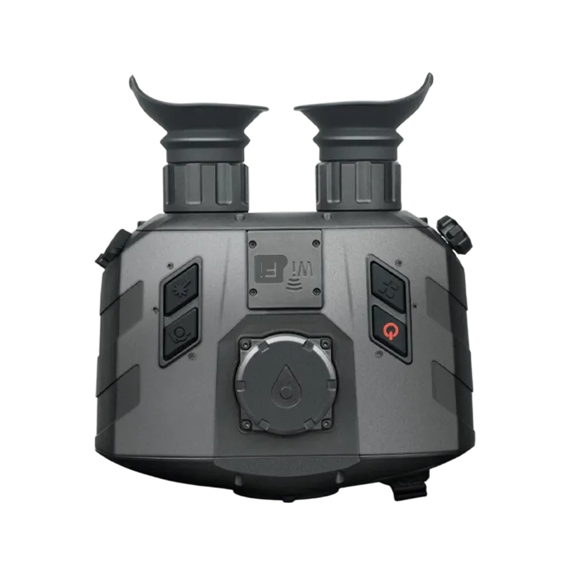
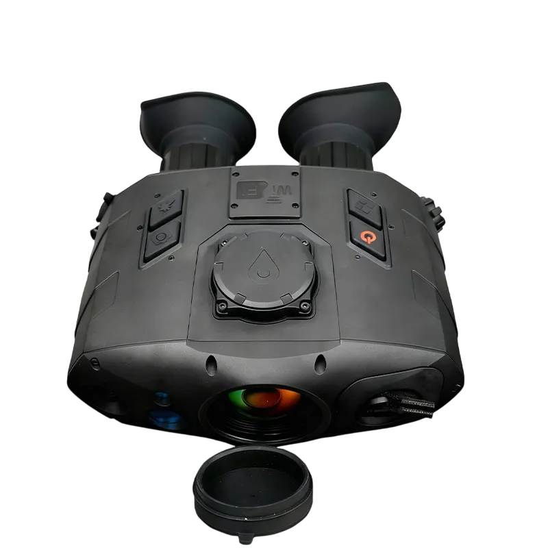
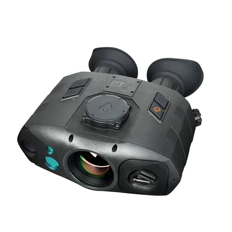
The HTM150 is a rugged, tactical handheld bi-ocular that fuses 6.2MP visible light and 0.8MP thermal imaging for uninterrupted 24/7 reconnaissance and target acquisition. Equipped with integrated GPS/BeiDou positioning, a digital compass, and a precise laser rangefinder, it delivers instant target geolocation and real-time multi-sensor data fusion. Engineered for extreme environments, it is the ultimate situational awareness tool for military, law enforcement, and search and rescue operations.
- Dual-Channel Fusion: 6.2MP visible sensor and 80k-pixel thermal imager for day/night operational readiness.
- Instant Geolocation: Integrated GPS/BeiDou, digital compass, and laser rangefinder for real-time target coordinate calculation.
- Encrypted Wi-Fi Streaming: Secure WPA2-encrypted hotspot for live video transmission and remote command control.
- Extended Field Endurance: Dual-source power architecture utilizing four 18650 batteries and seamless external DC input.
- Tactical Power Saving: Built-in smart proximity sensor automatically toggles the display to prevent light leakage and conserve power.
- Combat-Ready Data Logging: One-touch photo/video capture with unalterable OSD metadata overlays for evidence gathering.
Seamless Day-Night Fusion Imaging
The HTM150 eliminates the logistical burden of carrying separate day and night optics. By blending a high-resolution 6.2MP visible sensor with a highly sensitive thermal core, operators can instantly switch between optical details and heat signatures via a dedicated hotkey. Whether identifying license plates in broad daylight or detecting targets through dense smoke, fog, and absolute darkness, the device ensures continuous tactical superiority.
One-Button Target Geolocation & Multi-Echo LRF
Manual range estimation is obsolete. With a single press, the integrated laser rangefinder accurately measures target distance, while the multi-echo selection logic isolates targets behind foliage or glass. When satellite signals are active, the onboard processor instantly cross-references the LRF, GPS/BeiDou, and digital compass data to calculate and display the target’s exact absolute coordinates (latitude, longitude, and elevation).
Adaptive Navigation & Digital Compass
Built for high-interference environments, the internal 3-axis digital compass provides precise azimuth, pitch, and roll data. The system features automatic magnetic declination correction using real-time satellite data, ensuring true north accuracy. Operators can select their preferred angular format (degrees, 6000/6400 mils, or grads) and perform rapid 3D spatial calibration to maintain precision in changing operational theaters.
Smart Power Architecture & Light Discipline
Mission failure due to power depletion is mitigated by a flexible, hot-swappable four-cell 18650 battery bay. A dynamic on-screen power icon provides real-time battery status warnings. For static or long-duration surveillance, the aviation port allows seamless switching to an external 5–9V DC power source without system interruption. Additionally, a display proximity sensor shuts off the screen the moment the user steps away, enforcing strict light discipline and extending battery life.
Secure Data Management & Intelligence Sharing
Capture high-definition JPG photos and AVI videos with a single button. The system automatically applies On-Screen Display (OSD) overlays—including time, GPS coordinates, zoom levels, and compass headings—to create court-admissible evidence and actionable intelligence. Files can be reviewed directly via the on-device playback UI, exported via a secure USB aviation cable to a PC, or streamed wirelessly over an encrypted Wi-Fi network.
| Parameter Category | Specification Detail |
| Model | HTM150 Handheld Multifunctional Fusion Thermal Imaging Reconnaissance Device |
| Visible Light Sensor | 6.2 megapixels |
| Thermal Sensor | 0.8 megapixels (80k pixels) |
| Image Modes | Infrared (white hot, black hot, pseudo-color), Visible light |
| Digital Zoom | 1.0x – 4.0x stepless (step 0.1) |
| Diopter Adjustment | -4D to +4D |
| Laser Rangefinder | Multiple echo support, single or continuous ranging |
| Ranging Unit | Meter / Foot |
| Positioning System | GPS / BeiDou / Dual-mode hybrid |
| Coordinate Systems | Geographic coordinate system, Gauss coordinate system (CGCS2000) |
| Coordinate Units | UTM, MGRS, Degree Minute Second, Degree Minute |
| Elevation Unit | Meter / Foot |
| Digital Compass | Azimuth, pitch, roll; angle units: Degree, Mils (6000/6400), Grads |
| Magnetic Declination | Manual or automatic (based on positioning) |
| Video Output | Micro HDMI (digital) |
| Wireless | Wi-Fi 802.11 b/g/n (AP mode), WPA2 or no encryption, custom password |
| Storage | Internal memory, supports photo (JPG) and video (AVI) |
| Photo / Video Overlay (OSD) | Optional on/off for time, coordinates, zoom, angles |
| Battery | 4 × 18650 (nominal 3.7V, range 2.5V–4.2V) |
| External Power | DC 5–9V via aviation connector |
| Interfaces | Aviation connector (DC/USB/RS232), Micro HDMI, 1/4″ tripod mount |
| Proximity Sensor | Yes (auto screen on/off) |
| Microphone | Built-in |
| Operating Temperature | Not specified, but all-weather design |
| Waterproof Protection | Splash-proof (battery cover must be properly locked) |
| Dimensions | Not specified (compact handheld) |
| Weight | Lightweight (not specified) |
| Accessories Included | Waterproof storage case, battery charger (optional), aviation cable, video cable, quick start guide, user manual |
Applications
Frequently Asked Questions
The HTM150 utilizes multi-sensor data fusion. When you target an object with the laser rangefinder, the device combines the distance data with your own GPS/BeiDou location and the heading from the digital compass. It instantly computes the exact latitude, longitude, and elevation of the target on the display.
The proximity sensor serves two vital tactical functions: it conserves battery power by turning off the display when not in use, and it enforces strict light discipline by preventing screen glare from illuminating the operator’s face in dark environments.
The HTM150 supports dual export methods. You can connect the device directly to a Windows PC using the secure ruggedized USB aviation cable to access it as a mass storage device, or download files wirelessly via the encrypted Wi-Fi network.
Yes. The HTM150 features multi-echo technology. In complex environments where a laser beam might hit tree branches or windows first, operators can manually select the desired return echo to ensure accurate distance measurement to the actual target behind the obstruction.
Very secure. The built-in Wi-Fi hotspot utilizes robust WPA2 encryption and supports a custom password up to 20 characters, preventing unauthorized interception of live surveillance streams during tactical team operations.