
Long-Distance, Angle & Azimuth Measurement System
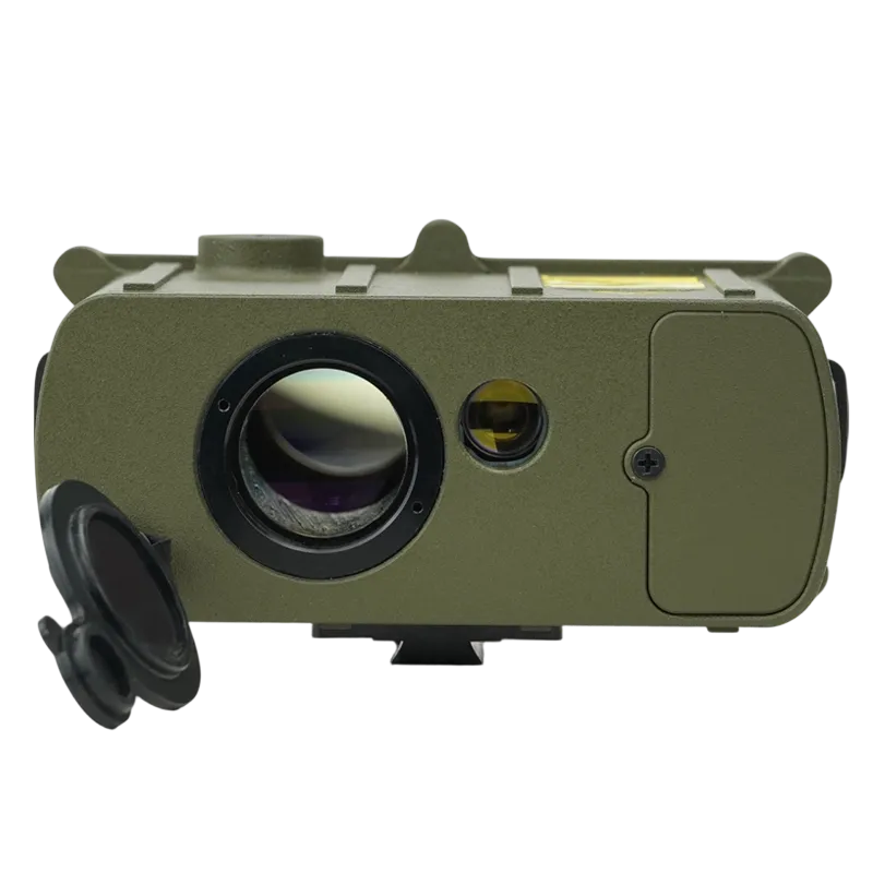

The TFN TKI Series is a professional long-range monocular laser rangefinder designed for accurate target measurement and observation in demanding field environments. With a maximum ranging capability of up to 6,000 meters, integrated distance, angle, and azimuth measurement functions, and advanced distance gating technology, it provides reliable data acquisition even in cluttered or complex terrain.
- Up to 6,000 m Laser Ranging Capability
- Distance Gating Function
- Horizontal & Vertical Distance Measurement
- Elevation Angle Measurement
- True North Azimuth Measurement
- 7× Optical Magnification
- Internal Storage for 1,000 Records
- Dustproof & Waterproof Construction
- Operating Temperature: -20°C to +50°C
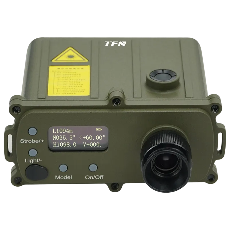
Measure Targets Accurately at Distances Up to 6 Kilometers
The TKI Series enables operators to obtain reliable distance measurements from 30 m to 6,000 m, making it possible to assess remote terrain, infrastructure, and observation targets without physically approaching the area. High ranging accuracy helps reduce measurement uncertainty and supports more confident decision-making in surveying, inspection, and tactical operations.
Eliminate False Readings with Distance Gating Technology
The adjustable gating function allows users to define a measurement threshold and ignore unwanted foreground reflections from objects such as vegetation, utility lines, terrain obstacles, rain, or atmospheric clutter. This ensures the laser prioritizes the intended target, improving measurement reliability in complex operational environments where conventional rangefinders often struggle.
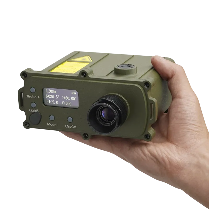
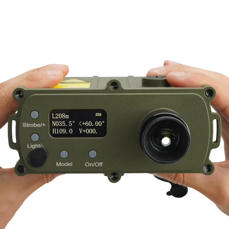
Capture Multiple Critical Measurements in a Single Observation
Beyond line-of-sight distance, the TKI Series simultaneously provides horizontal distance, vertical distance, elevation angle, and azimuth data. By combining multiple measurement functions into one device, operators can rapidly evaluate terrain, calculate clearances, determine target orientation, and collect positioning data without carrying separate instruments.
Maintain Situational Awareness with Integrated Azimuth Measurement
The built-in digital compass provides accurate azimuth readings referenced to true north, allowing users to determine target direction and orientation while measuring distance. This capability supports navigation, reconnaissance, target reporting, route planning, and field coordination where directional awareness is critical.
Observe Distant Targets with Enhanced Optical Clarity
A high-transmission, low-dispersion optical system delivers bright, sharp images with excellent contrast across varying light conditions. Combined with 7× magnification and a wide field of view, the TKI Series enables faster target acquisition and more precise aiming when observing distant structures, terrain features, or moving objects.
Comfortable Viewing for Extended Field Operations
The adjustable diopter eyepiece accommodates users with myopia, hyperopia, or presbyopia, allowing clear viewing without relying on corrective eyewear. This user-focused optical design helps reduce eye fatigue during prolonged observation and measurement tasks in the field.
Store and Review Critical Measurement Data
With internal memory capable of storing up to 1,000 measurement records, the TKI Series allows operators to capture, organize, and review field data without manual note-taking. This improves workflow efficiency, reduces transcription errors, and simplifies post-mission analysis.
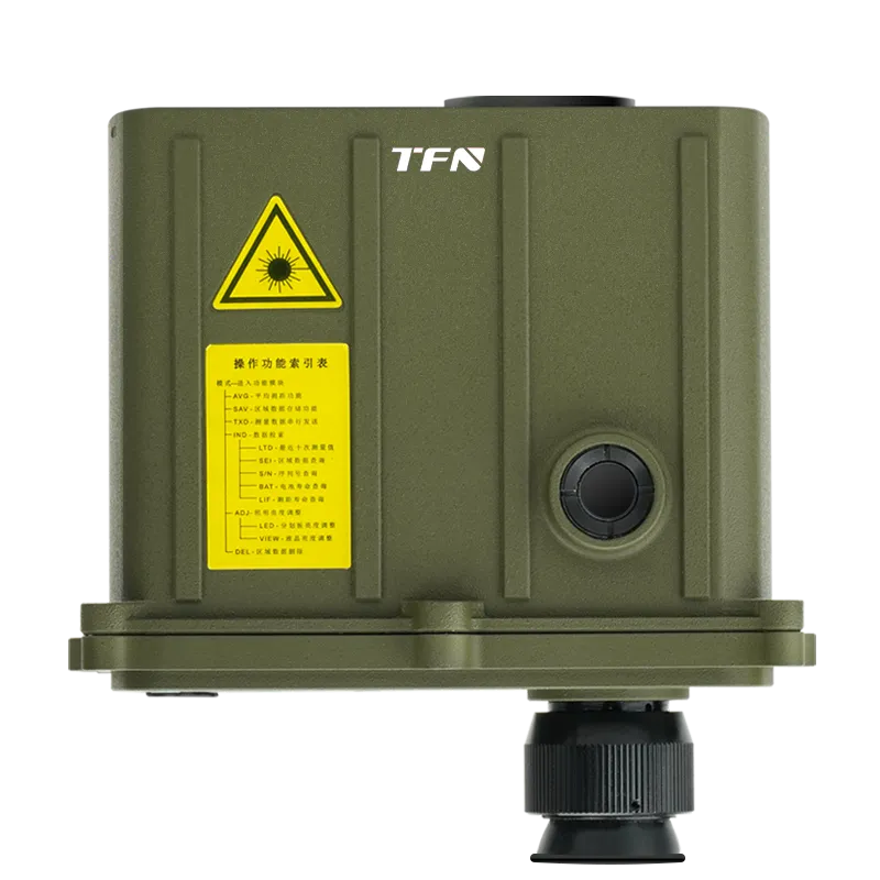
Built for Harsh Outdoor and Tactical Environments
Designed for reliable performance in demanding conditions, the TKI Series features a rugged dustproof, waterproof, and shock-resistant housing capable of operating in temperatures from -20°C to +50°C. Whether deployed in deserts, forests, mountainous regions, or coastal environments, it delivers dependable performance where mission success depends on reliable equipment.
| Parameter | Details |
| Product Model | TKI Series |
| Measurement Range | 30 ~ 6000 meters |
| Ranging Error | ±0.5 m |
| Distance Gating Range | 20 ~ 5100 meters ( adjustable step: 10 meters ) |
| Hit Probability | 98% |
| Repetition Frequency | 1/6 ~ 1/3 Hz (10 ~ 20 times/min) |
| Compass Accuracy | ±1 degree |
| Tilt Angle Accuracy | ±0.1 degree (within ±25°) |
| Measurement Data Storage | 1000 records |
| Receiving Aperture | φ30 mm |
| Sight Field of View | 6.5° |
| Sight Magnification | 7X |
| Laser Wavelength | 1.064 μm |
| Laser Source | Nd:YAG |
| Output Energy | ≥5 mJ |
| Operational Life (laser) | ≥20,000 shots |
| Working Temperature | -20℃ ~ +50℃ |
| Environmental Protection | Dustproof, waterproof, shock-resistant |
| Dimensions (L×W×H) | 151 mm × 149 mm × 79 mm |
| Weight | 1 kg |
| Power Supply | 1×18650 Li-ion battery (3.7V, 3400 mAh) |
Applications
Long-Range Reconnaissance and Observation: Measure distances to terrain features, vehicles, structures, and observation points while maintaining safe stand-off distances during reconnaissance missions.
Border Surveillance and Security Operations: Support perimeter monitoring, target assessment, and situational awareness across large border zones and restricted areas.
Artillery and Fire Support Observation: Provide accurate target distance, azimuth, and elevation data to support observation teams and battlefield target reporting.
Military Route Reconnaissance: Assess terrain features, obstacle dimensions, approach routes, and operational corridors during mission planning and movement operations.
Search and Rescue Missions: Rapidly determine distances, slopes, and target locations in mountainous, wooded, or disaster-affected environments to improve rescue coordination.
Frequently Asked Questions
A laser rangefinder combines traditional monocular / binocular observation with an integrated laser distance measurement system, allowing users to observe and measure targets using a single device.
Distance gating is a feature that filters out unwanted foreground reflections and allows the rangefinder to prioritize targets within a specified distance range. This improves measurement accuracy in environments containing vegetation, wires, rain, or other obstructions.
Yes. In addition to distance measurement, the TKI Series provides elevation angle measurement and true north azimuth measurement, enabling more comprehensive terrain and target analysis.
Unlike basic rangefinders that only provide distance measurements, the TKI Series combines long-range laser ranging, distance gating, horizontal and vertical distance calculation, elevation angle measurement, azimuth measurement, and onboard data storage in a single professional-grade device.
Yes. The TKI Series is designed for operation in demanding outdoor conditions with dust-proof, waterproof, and shock-resistant construction and an operating temperature range of -20°C to +50°C.